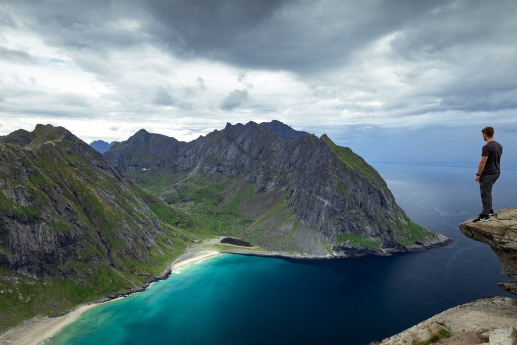
The hike to the top of Ryten (543 meters) in the Lofoten Islands offers one of the best views of the incredible white sand and soaring cliffs of Kvalvika Beach.
The Ryten hike is a moderate 3-5 hour round-trip trek to a small mountain peak accessible to many fitness levels with a clear, well-marked trail near the village of Fredvang.
After doing several hikes in Lofoten, this is one of my personal favorites for its easier climb and the unique rocky outcrop at the top of Ryten, reminiscent of a small Trolltunga, where you can take great photos overlooking Kvalvika Beach.
Ryten Hiking Details
Below is a detailed overview of what you need to know about this hike. Continue reading for advice on how to get to the trailheads, the best photo opportunities, and what to expect.
- Starting Points: Trailhead
- Parking: Innersand - costs 100 NOK to park a vehicle with an extra cost of 100 NOK for an overnight stay. Free option available (more below).
- Hike Distance: 7 km round trip.
- Elevation Gain: 543 meters to the top of Ryten.
- Difficulty Level: Easy - Moderate - this is an easy hike by Norwegian standards but you need a decent level of fitness to reach the top.
- Duration: Approximately 3 to 5 hours.
- Best Time to Hike: Late spring to early autumn for the best weather and daylight. Can be hiked all year with the right gear.
- Trail Type: Well-marked path with a steady incline and some rocky sections. Can get wet and boggy, wooden planks are installed in sections to protect the flora.
- Full hike data: My Strava
Ryten is a very popular hike so you can expect to see many other hikers, especially during the peak seasons. Therefore, I recommend doing this one early in the morning for the best views. Heavy fog often rolls in during the late afternoons.

Where is Ryten
Ryten is located in Moskenesøya within Lofotenodden National Park in the Lofoten Islands, above the Arctic Circle in Nordland County, Norway. There are two ways to climb to the top of Ryten; the direct route near Ytresand, and via Kvalvika Beach.
In this post, I'll cover how to hike Ryten directly as I did. This route starts at a small car park at the end of "FV806" near the village of Fredvang, accessible via the Fredvang Bridges, which connect to the rest of Lofoten.
The trailhead is approximately 30 minutes north of Reine.
Trailhead GPS Coordinates: 68°05'19.2"N 13°08'21.7"E

How to Get to the Trailhead
Below are the two options to get to the trailhead to begin the hike.
- Drive: The best way to get to Ryten is to drive directly to the trailhead pinned above where you will find a dedicated parking lot for the hike at the end of a narrow road. However, parking costs 100 NOK per vehicle. Alternatively, another free parking area is available nearby which I'll discuss below.
- Public Transport: Buses are running to Fredvang from popular areas like Å and Reine. However, there are not many buses that go through Fredvang so I recommend using ReisNordland to plan carefully to ensure you get back in time for a bus. Alternatively, you could stay around Ramberg.
I hiked Ryten with my two friends Ryan and Jessy as a small adventure during our 2,500 km charity bicycle ride across Norway. We stayed at the nearby camping area called Fredvang Strand- og Skjærgårdscamping and rode to the trailhead from there (you can also walk in around 25 minutes).
Parking
Currently, there are two parking areas where you can leave your car to start the Ryten hike, a paid and free option. Even the paid one isn't an "official" one but is run by locals using their grass as a parking lot.
Tip: I recommend the first paid parking option as it is the closest to the trailhead.
Parking Area 1: Innersand
- Parking fee: 100 NOK with an additional 100 NOK overnight stay fee
- GPS coordinates: 68°05'19.2"N 13°08'21.7"E
- Facilities: Toilet, fresh drinking water & washing facilities, sorted garbage disposal, seating areas
The first and closest parking lot to the Ryten trailhead is at Innersand at the end of FV806 road leading from the Fredvang bridges. Simply cross the bridges and continue on this road as it curves around. A few hundred meters ahead, watch for a large grassy parking area signposted on the road's left side.
This is right beside the Peat Museum at Fredvang pinned as Torvmuseet på Fredvang on Google Maps.

Parking Area 2: Fredvang Skole (School)
- Parking fee: Free
- GPS coordinates: 68°05'20.0"N 13°10'23.4"E
- Facilities: None
The free parking for the Ryten hike is located about 2 km away from the starting point near the local school.
This is a good way to save a bit of money but adds around an hour to the hike overall. You also cannot leave your car here overnight. Alternatively, Fredvang Kirkegård (church) also has a small parking area with a similar distance overall to the trail.
My Experience Hiking to the Top of Ryten (Step by Step)
From the parking lot near Peat Museum, we saw a National Park sign with a gravel path leading in the direction of the Ryten trailhead. We followed the sign along this path through the meadow alongside a wire fence.

Shortly after, we got to a set of steel gates designed to keep livestock in. This is where the trail begins to steepen for the first climb. The trail is very easy to follow as it is well-worn, especially when we hiked during the summer months.
Once we made it to the top of the first climb, we stopped for a quick rest and to enjoy the views of the meadows and parking lots below.


Fork at the Tarn (Forsvatnet)
Shortly after the first climb, the trail turns right and leads to a small tarn (mountain lake) known as Forsvatnet.

Shortly after there is a fork and it is signposted (Ryten and Hytte). The left path detours down to Kvalvika Beach and the right trail leads to a small hut (Fredvanghytte) on the top of a hill.

Since we wanted to hike directly to the summit, we continued straight through, ignoring these turns.
The path cuts through this relatively flat section following the wooden plank bridges that saved us from the wet feet due to the rather boggy underfoot.


Final Push to the Top of Ryten
The final stretch to Ryten climbs the side of its gently sloping, grassy face. There is a worn trail leading up the hill that is very easy to follow, at least in summer when we hiked.
This section is the steepest of the hike but not overly difficult. The view got better and better as we ascended, passing some grazing sheep on the way.


View from the Top of Ryten
You'll know when you've reached the summit of Ryten (543 meters above sea level) when it levels out and you see some small boulders and rocky outcrops. Well, that, or potentially the dozens of hikers lining up to get a photo of the incredible view (yes, this is a busy trail in summer).
Regardless, the views at Ryten over Kvalvika Beach easily make this hike worth it, with a truly stunning landscape that is beginning to be the poster boy for the Lofoten Islands.

Views span 360-degrees. Of course, the main event is Kvalvika Beach and its towering, jagged peaks dropping almost vertically down to its golden shores. But, if you turn around, you'll see great views of the Fredvang Bridges and the surrounding mountains and small lakes to the south.
During my visit, the lighting conditions for photography were less than ideal. This was because during the Norwegian Summer, the sun doesn't really set here and we weren't prepared to hike at 12 am for the midnight sun to give us nice light! Still, we managed to get some nice photos.

The Ryten Cliff Photo Spot
The Ryten hike is famous for the rocky cliff viewpoint where you can stand on a rock overlooking the beach. In the photo, you can make it look like you are standing on a thin slab of rock on the edge of a cliff, much like in Trolltunga.
However, in reality, there are more rocks under this "rock" so it is much safer than both Trolltunga and Kjeragbolten since it isn't a vertical drop beneath.
Note that the majority of hikers who make it to the summit will want to take this photo. So, unfortunately, there are sometimes lineups similar to the other famous hiking photo spots in Norway.


Descending to the Second Rocky Outcrop at Ryten
Since we didn't want to wait in line for a photo, we decided to look for another viewpoint. Standing near the cliff viewpoint, we looked down to the right, where there is a large rocky outcrop with a flat top that nobody was hiking to.
So, I climbed down the dirt path to its base, where I next did some light scrambling to reach the top. The breathtaking views from here in my opinion were much better and free from any other tourists. However, I'd say that getting to this spot is much more dangerous and slippery. Remember, you are responsible for your own safety.


The Descent
After spending about an hour at the top, we made the return trip back to the parking lot where our bicycles were waiting. Unfortunately, heavy clouds and fog had begun rolling in, which is typical of afternoons in this part of Lofoten.

To get back to the parking lot, we followed the same hiking trail back down, which was much easier than the way up. Our original plan was to extend this hike down to the beautiful Kvalvika Beach via the fork near the tarn.


Optional: Hiking Ryten via the Kvalvika Beach Hike
It is possible to combine the hike to the top of Ryten with a trip down to the golden shores of Kvalvika Beach. This involves the same start and finish point near Innersand and takes around 5-6 hours for the return trip spanning 12.5 km.
You will find the is a detour down to the beach at approximately the 2.2 km mark near the lake (Forsvatnet).

Where to Stay in Lofoten
Lofoten accommodation is known for its picturesque fishing villages. Many choose to stay in Reine or Svolvær for their authentic charm & proximity to outdoor activities. Below are my three top picks.

1. Lofoten Cabins - Kåkern Top-Choice
Sleeping up to six people it's the perfect choice for large groups. All are fully equipped and offer living areas. The cabins are situated near many hiking trails.

2. Eliassen Rorbuer Popular Pick
Renovated fisherman cottages located on the Hamnøy harbor. Boasting fully equipped kitchens and living areas with breathtaking views over the Vest Fjord.

3. Sakrisøy Gjestegård Mid-Range
A beautiful 1880 house situated on the shores of Reine Fjord. Offering large rooms with spectacular views over the surrounding ice-capped mountains.
FAQ About the Ryten Hike
When is the best time of year to hike Ryten?
You can complete this hike at any time of the year. However, the best time to hike Ryten is from late spring to early autumn for optimal weather and daylight conditions. Note, this is the high season so expect a lot of foot traffic. Winter hikes are possible with proper gear & experience including snowshoes.
How difficult is the Ryten hike?
The hike is rated as easy to moderate and is much easier than other hikes in Lofoten with similar views. It's accessible to those with a decent fitness level, but the trail does include some steep and rocky sections.
Are there any fees associated with the Ryten hike?
Yes, parking at the Innersand parking area costs 100 NOK per vehicle, with an additional 100 NOK for overnight stays. The second parking option at Fredvang Skole is free.
Can I bring my dog on the Ryten hike?
Yes, dogs are allowed on the Ryten hike but should be kept on a leash to protect wildlife and livestock. There are many sheep in this area.
What should I pack on the Ryten hike?
Essential items include water, snacks, a map or GPS device, and weather-appropriate clothing including rainwear and sturdy hiking boots. Don't forget your camera for the summit!
How do I get to the Ryten hike trailhead?
The trailhead is accessible by car, with parking available at Innersand (paid) and Fredvang Skole (free), or by public transport with infrequent connecting buses running to Fredvang from popular Lofoten towns including Å and Reine.
Can I camp along the trail?
Wild camping is allowed in Norway under the Right to Roam law, but remember to camp responsibly away from the main hiking trail and follow Leave No Trace principles. The most popular camping spot is at Kvalvika Beach, with many hikers choosing to hike to Ryten from there in the early morning.
Is Ryten worth it?
After doing many hikes in the Lofoten Islands, including the famous Reinebringen Hike, I still think that Ryten is one of the best hikes in Northern Norway. This is because Ryten is one of the easiest hikes available to get such stunning coastal views.

More Useful Guides for Your Norway Trip
I hope this Ryten hiking guide has been helpful for planning your adventures in the Lofoten Islands!
Remember, I'm constantly updating my travel guides to ensure I'm sharing the most up-to-date information with my readers. If you have any updates, please leave a comment below!
Otherwise, check out some of my other guides below for more inspiration for your trip to Norway.


